1860 - Congressional pamphlet detailing the expedition to find a shortcut between the Great Salt Lake and the Oregon Trail
Washington DC: U.S. Senate, 1860. Disbound. 36th Congress, 1st Session. Senate. Ex. Doc., No. 34. Report of the Secretary of War communicating In compliance with a resolution of the Senate, the report of Captain H. D. Wallen of his expedition in 1859, from Dalles City to Great Salt Lake, and back. April 11, 1860.
51 pages plus a 22” x 16” folded map. Removed from a bound volume. Tight and clean with some light toning, mostly at the edges. Bottom corner of one leaf missing; affects about twenty-five words of text. In nice shape, much better than usually found.
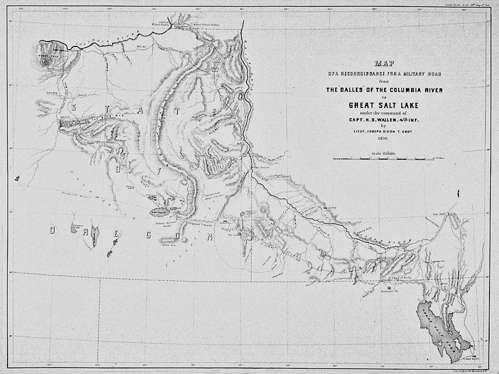
The pamphlet’s map, titled: Map of a Reconnaissance for a Military Road from the Dalles of the Columbia River to Great Salt Lake under the command of Capt. H. D. Wallen, 4th Inf. By Lieut. Joseph Dixon T. Engrs. 1859, is in nice shape with binding folds. It would have been too difficult to unfold for a photograph without possibly loosening it from the binding, so the accompanying image, which I believe is in the public domain, is of another map in similar condition.
"The road was surveyed through new country for the benefit of emigrants and prospective settlers. They departed from The Dalles on June 4, and arrived at Camp Floyd, Utah Territory, on August 16. They left Camp Floyd on August 20 and returned to The Dalles. In addition, detachments of the command explored much of central-eastern Oregon. Wallen speaks of travelers being harrased by Indians on the California road during the summer just past." (Wagner-Game: The Plains & the Rockies; see also Graff 4525 and Howes W57)
The “Reconnaissance for a Military Road” at the online Oregon History Project goes on to expand:
“During the 1840s and 1850s, tens of thousands of emigrants traveled across the Oregon Trail . . .. Most of them followed a route along the Snake River before heading northwest towards the Grande Ronde Valley [and] across the Blue Mountains to the Umatilla Valley, then west towards The Dalles. From The Dalles emigrants faced the choice of either following the Barlow Road across the Cascades or taking the water route down the Columbia River. . .. Most chose the Barlow Road, though winter weather forced many to take the more dangerous river route. The portion of the Oregon Trail that crossed the Blue Mountains was generally inaccessible during the winter months. . .. Indian wars of the late 1850s led General William S. Harney, commander of the U.S. Army’s Oregon Department, to recommend the establishment of an all-season supply route from Salt Lake to the Columbia River in order to speed troop movement and to secure the emigrant route, [and he] ordered Captain Henry D. Wallen to ‘open a road from the Dalles to the Great Salt Lake valley. . . The routes explored by the Wallen expedition turned out to be unsuitable for wagon travel, but [the expedition]] did succeed in gaining a significant amount of geographical knowledge about a little known portion of Oregon’s interior.”
. Very good. Item #009859Rather scarce. At the time of listing, two examples in lesser condition are for sale in the trade. The Rare Book Hub records eight auction sales in the last 75 years. OCLC records suggest that about 30 examples are held by institutions, although some of these could well be microform or digital copies.
Price: $275.00